Published papers in international journals
1. Baggs Sargood M, Cohen TJ, Thompson CJ, Croke JC. 2015. Hitting rock bottom: morphological responses of bedrock-confined streams to a catastrophic flood. Earth Surface Dynamics 3(2): 265-279
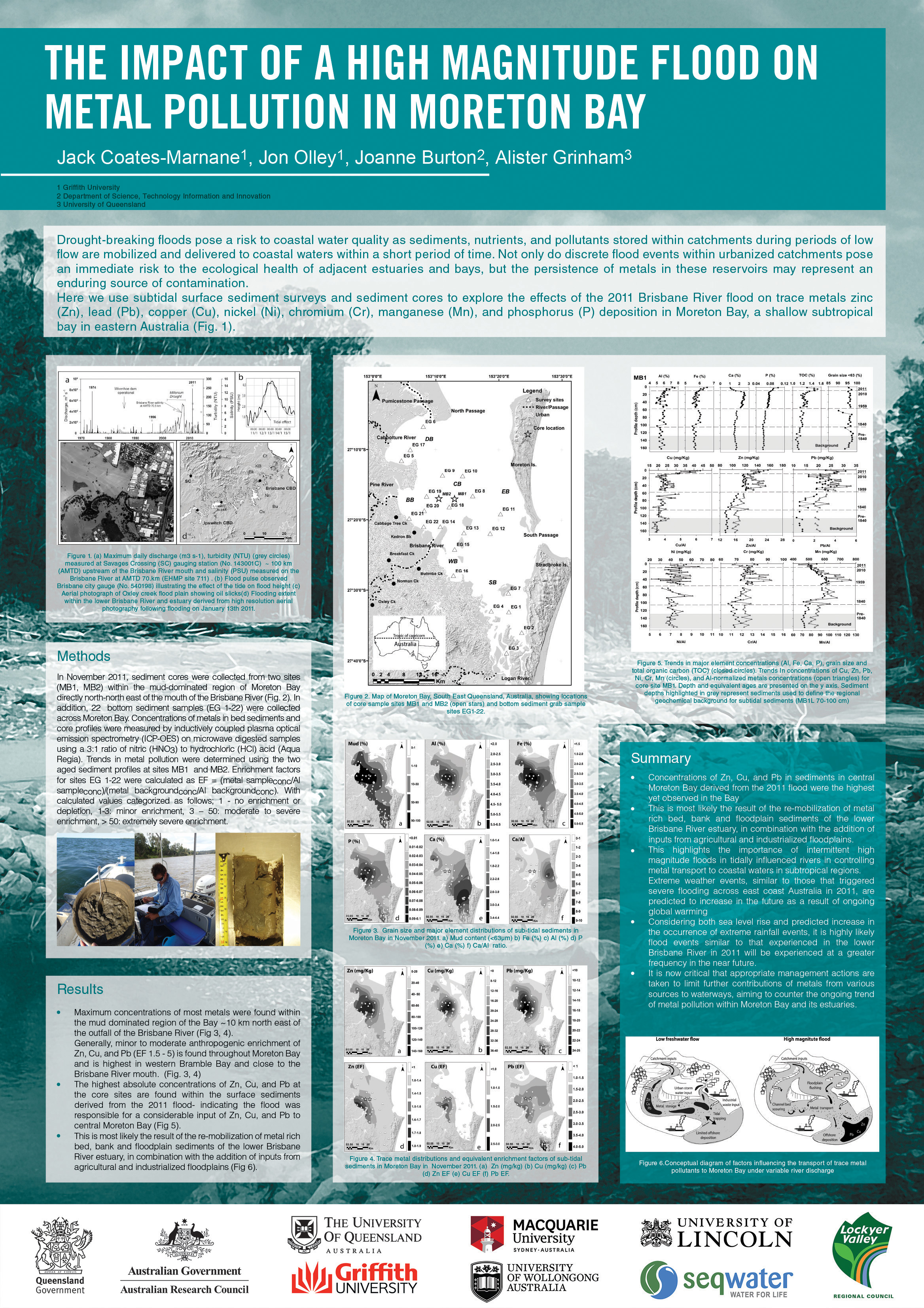
2. Coates-Marnane J, Olley JM, Burton J, Grinham A. 2016a. The impact of a high magnitude flood on metal pollution in a shallow subtropical estuarine embayment. Science of the Total Environment 569-570: 716-731
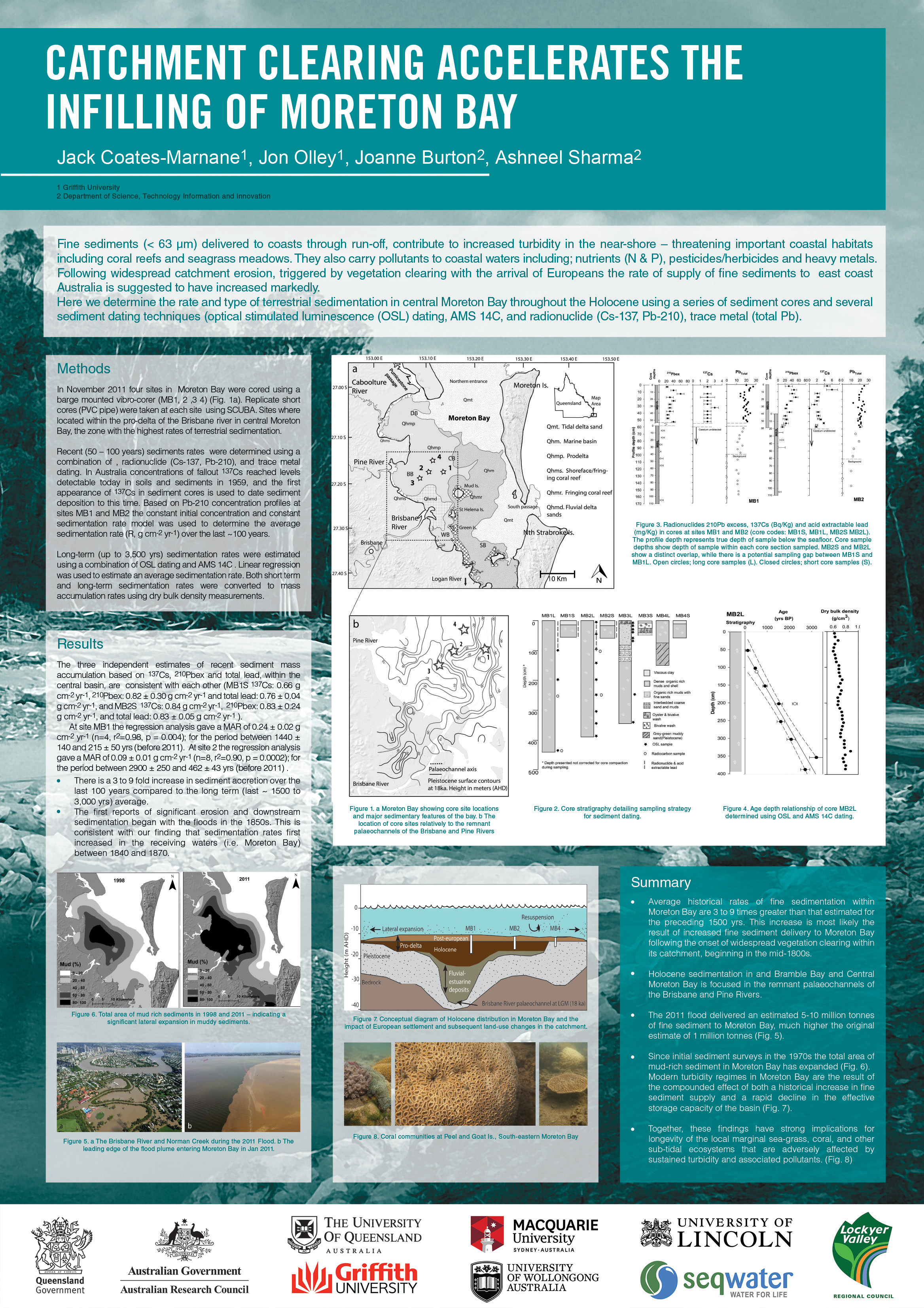
3. Coates-Marnane J, Olley JM, Burton J, Sharma A. 2016b. Catchment clearing accelerates the infilling of a shallow subtropical bay in east coast Australia. Estuarine, Coastal and Shelf Science 174: 27-40
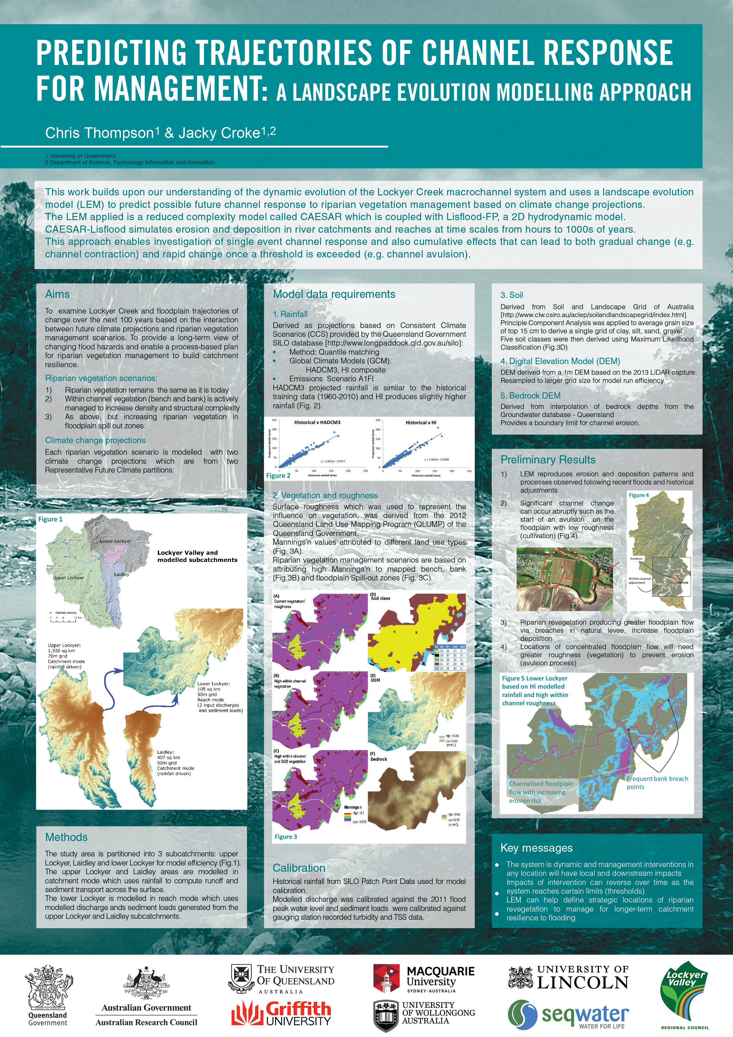
4. Croke JC, Thompson CJ, Fryirs KA. 2017. Prioritising the placement of riparian vegetation to reduce flood risk and end-of-catchment sediment yields: Important considerations in hydrologically-variable regions. Journal of Environmental Management
5. Croke JC, Fryirs KA, Thompson CJ. 2016a. Defining the floodplain in hydrologically-variable settings: implications for flood risk management. Earth Surface Processes and Landforms
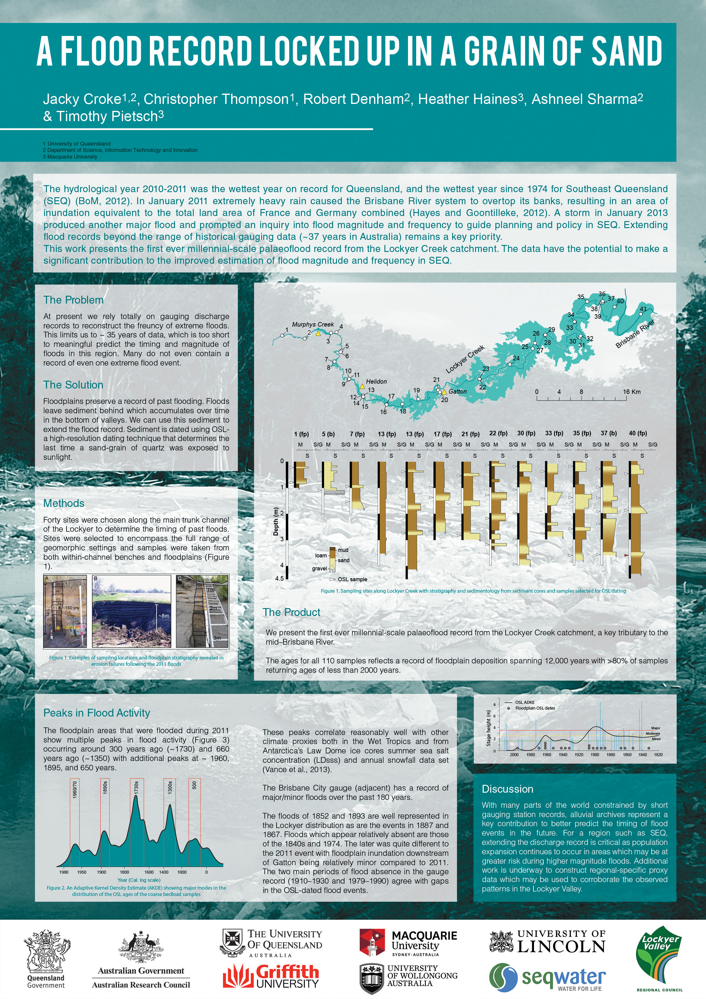
6. Croke JC, Thompson CJ, Denham R, Haines HA, Sharma A, Pietsch T. 2016b. Reconstructing a millennial-scale record of flooding in a single valley setting: the 2011 flood-affected Lockyer Valley, SEQ, Australia. Journal of Quaternary Science
7. Croke JC, Denham R, Thompson CJ, Grove JR. 2015 Evidence of self-organized criticality in riverbank mass failures: a matter of perspective? Earth Surface Processes and Landforms 40(7): 953-964
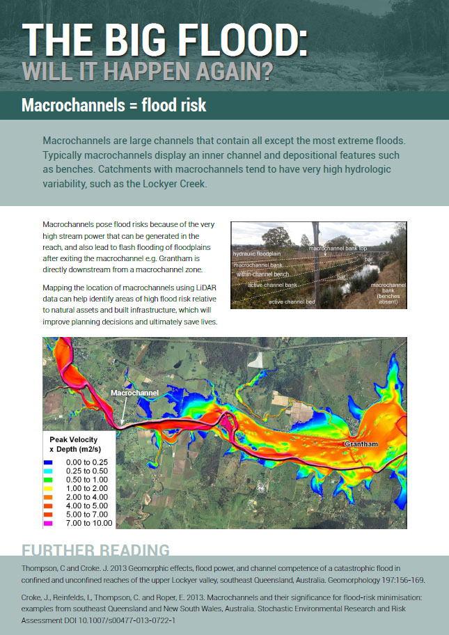
8. Croke JC, Reinfelds I, Thompson CJ, Roper E. 2014. Macrochannels and their significance for flood-risk minimisation: examples from southeast Queensland and New South Wales, Australia. Stochastic Environmental Research and Risk Assessment 28(1): 99-112
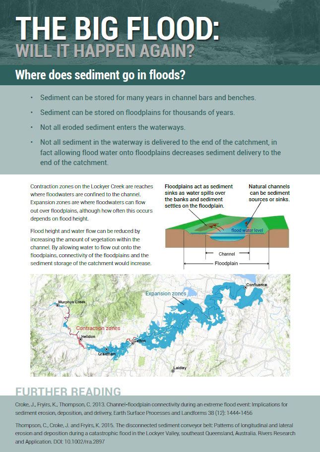
9. Croke JC, Fryirs KA, Thompson CJ. 2013a. Channel-floodplain connectivity during an extreme flood event: Implications for sediment erosion, deposition, and delivery. Earth Surface Processes and Landforms 38: 1444–1456
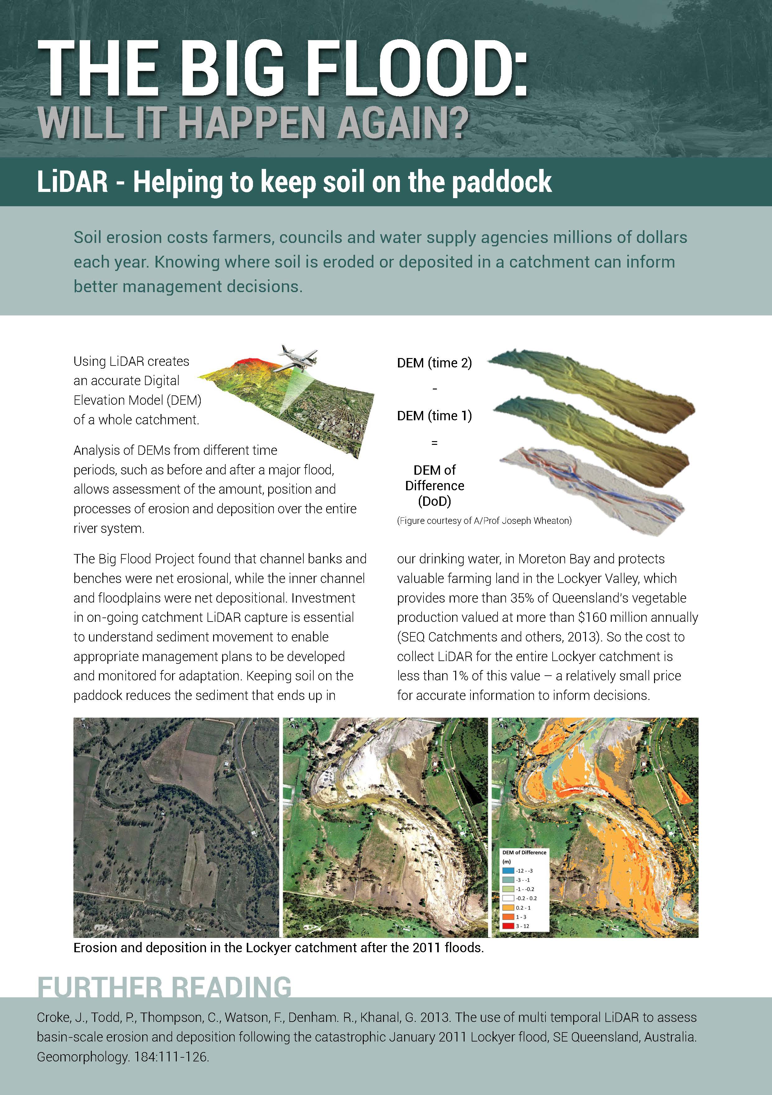
10. Croke JC, Todd P, Thompson CJ, Watson F, Denham R, Khanal, G. 2013b. The use of multi temporal LiDAR to assess basin-scale erosion and deposition following the catastrophic January 2011 Lockyer flood. Geomorphology 184: 111-126
11. Daley JS, Croke JC, Thompson CJ, Cohen TJ, Macklin M, Sharma A. 2017. Late Quaternary channel and floodplain formation in a partly confined subtropical river, eastern Australia. Journal of Quaternary Science
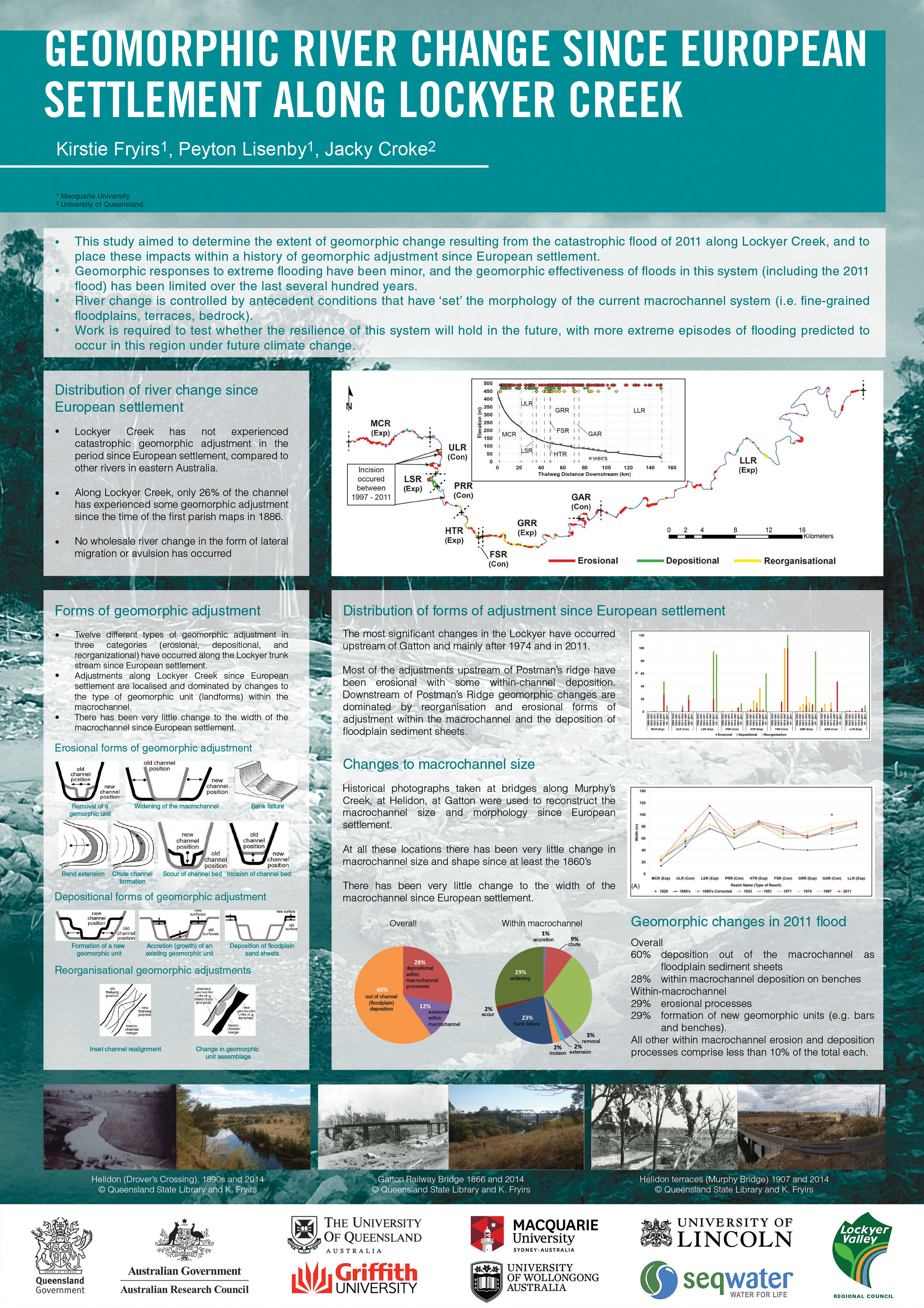
12. Fryirs KA, Lisenby P, Croke JC. 2015. Morphological and historical resilience to catastrophic flooding: The case of Lockyer Creek, SE Queensland, Australia. Geomorphology
13. Grove JR, Croke JC, Thompon CJ. 2013. Quantifying different riverbank erosion processes during an extreme flood event. Earth Surface Processes and Landforms 38(12): 1393-1406
14. Haines HA, Olley JM, Kemp J, English NB. 2016. Progress in Australian dendroclimatology: Identifying growth limiting factors in four climate zones. Science of the Total Environment 572: 412-421
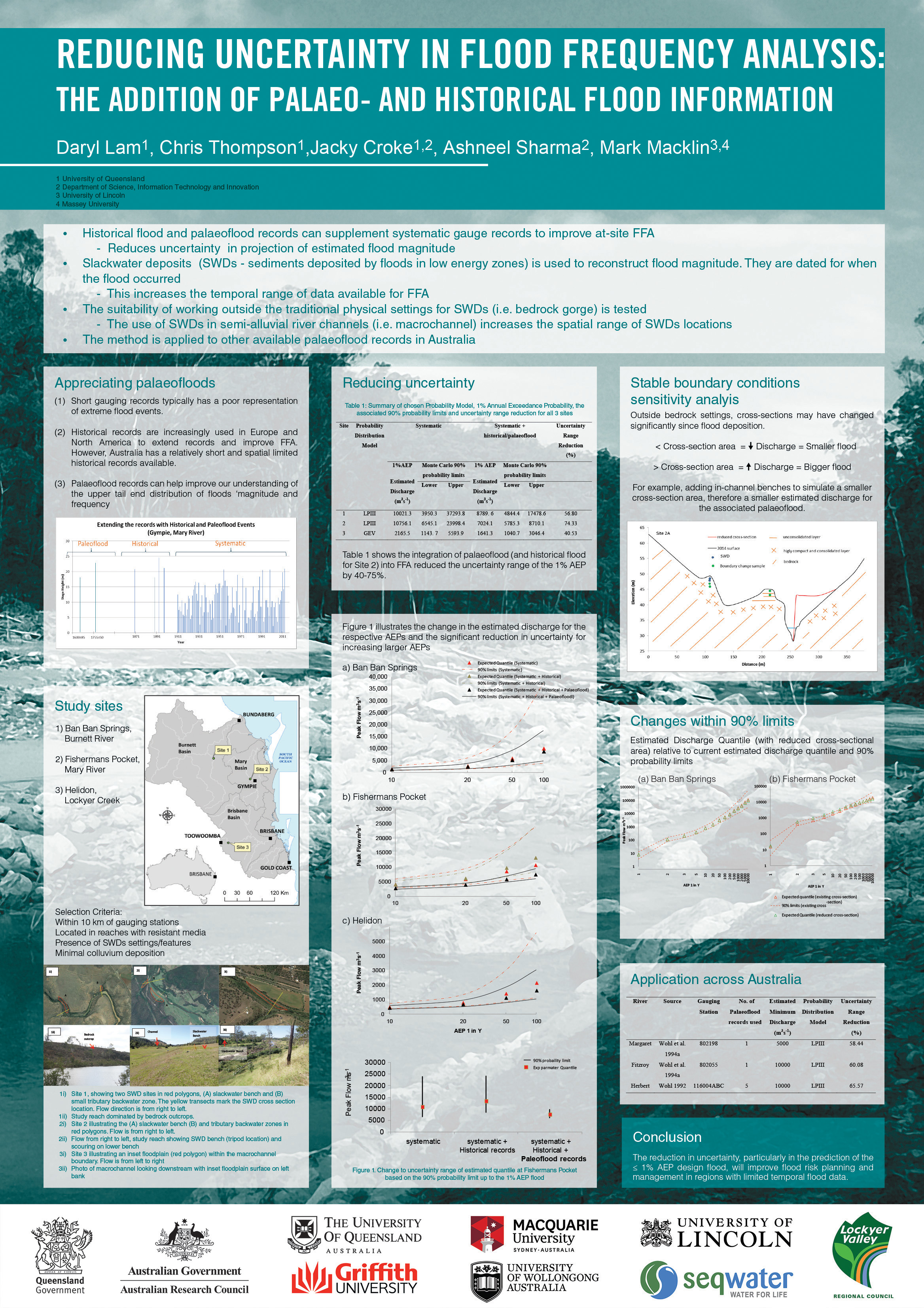
15. Lam, D, Thompson CJ, Croke JC, Sharma A, Macklin M. 2017. Reducing uncertainty with flood frequency analysis: the contribution of palaeo- and historical flood information. Water Resources Research
16. Lam D, Thompson CJ, Croke JC. 2016. Improving at-site flood frequency analysis with additional spatial information: a probabilistic regional envelope curve approach. Stochastic Environmental Research and Risk Assessment 1-21
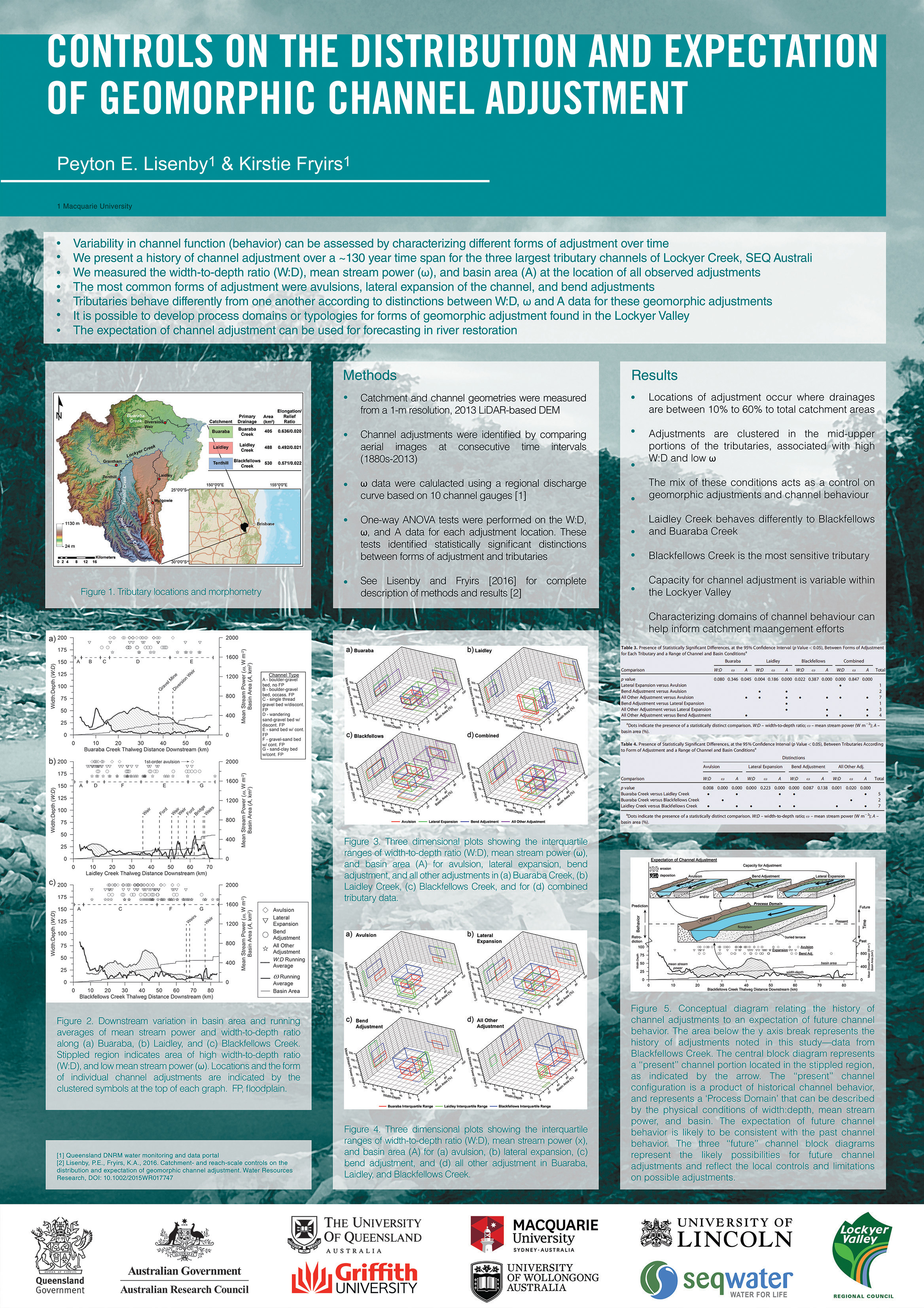
17. Lisenby PE, Fryirs KA. 2016. Catchment- and reach-scale controls on the distribution and expectation of geomorphic channel adjustment. Water Resources Research 52(5): 3408–3427
18. Lisenby PE, Croke JC, Fryirs KA. 2017. Geomorphic Effectiveness: A Linear Concept in a Non-Linear World. Earth Surface Processes and Landforms
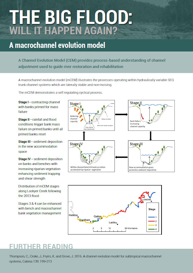
19. Thompson CJ, Croke JC, Fryirs KA, Grove JR. 2016a. A channel evolution model for subtropical macrochannel systems. Catena 139: 199-213
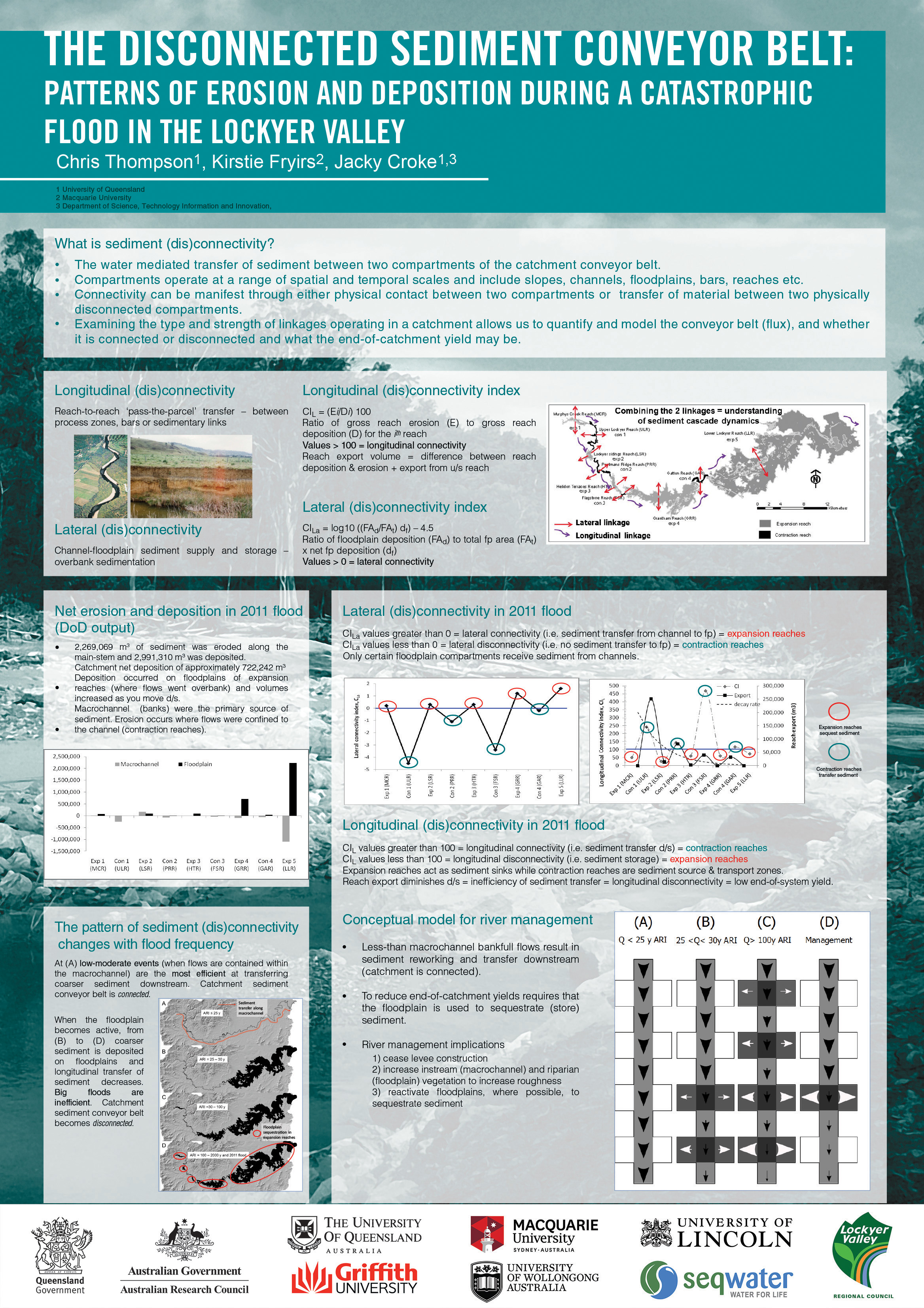
20. Thompson, C. J., Fryirs, KA. and Croke, J. 2016b. The Disconnected Sediment Conveyor Belt: Patterns of Longitudinal and Lateral Erosion and Deposition During a Catastrophic Flood in the Lockyer Valley, South East Queensland, Australia. River Research and Applications 32(4): 540-551.
21. Thompson CJ, Croke JC. 2013. Geomorphic effects, flood power and channel competence of a catastrophic flood in confined and unconfined reaches of the upper Lockyer valley, south east Queensland, Australia. Geomorphology 197: 156-169
22. Thompson CJ, Croke JC, Grove JR, Khanal, G. 2013. Spatio-temporal changes in riverbank mass failures in the Lockyer valley, Queensland, Australia. Geomorphology 191: 129-141
Papers in review
23. Croke JC, Thompson CJ, Larsen A, Sharma A. Submitted. The nature and timing of fluvial response to changing base-level and climate over the last glacial -interglacial cycle in sub-tropical Australia. Quaternary Science Reviews
24. Croke JC, Thompson CJ, Fryirs KA. Submitted. Using estimates of stream power to predict channel erosion during an extreme flood event. Water Resources Research
25. Haines HA, Olley JM. Submitted. The implications of regional variations in rainfall for reconstructing rainfall patterns using tree rings. Hydrological Processes
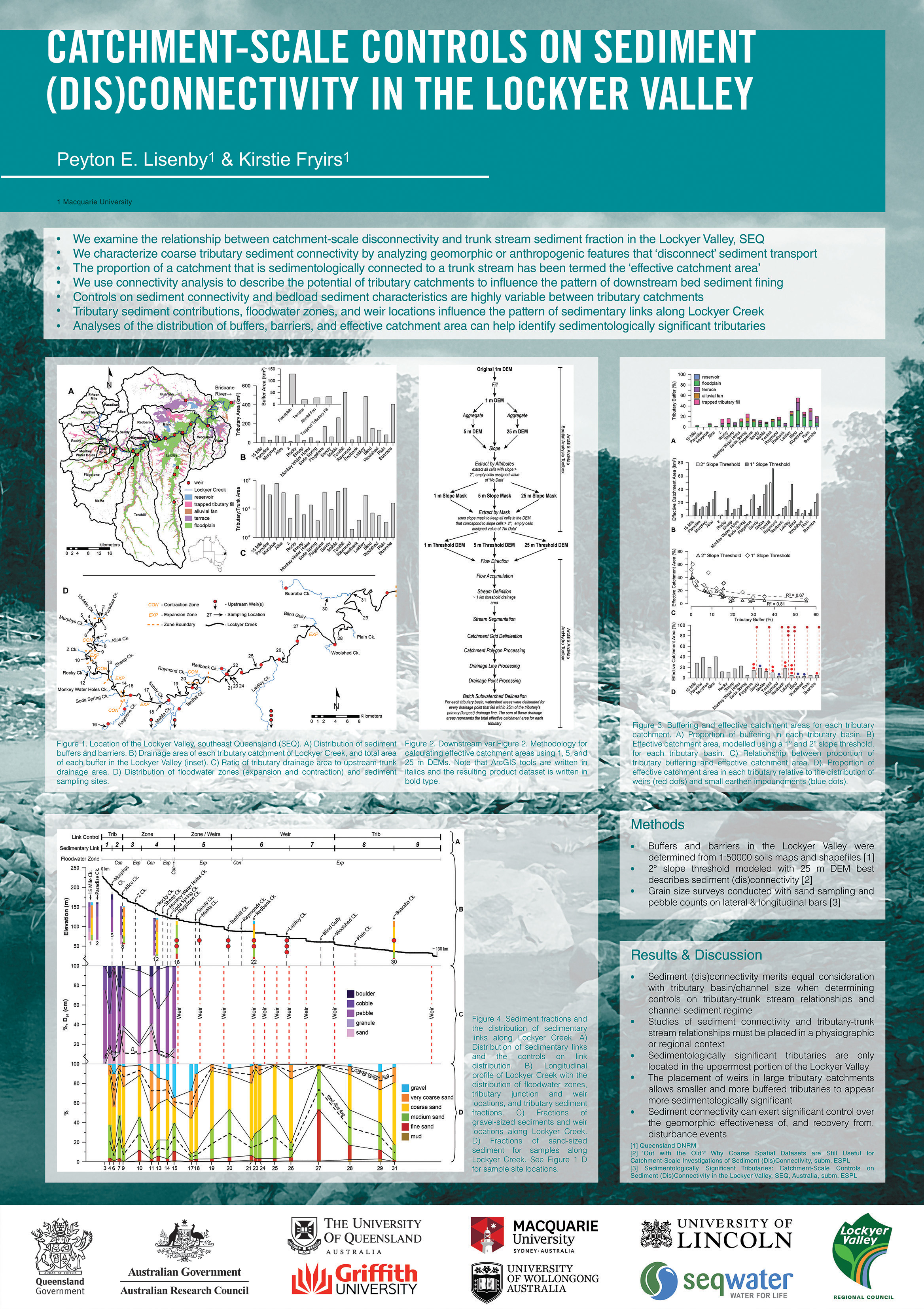
26. Lisenby PE, Fryirs KA. Submitted. Sedimentologically Significant Tributaries: Catchment-Scale Controls on Sediment (Dis)Connectivity in the Lockyer Valley, SEQ, Australia. Earth Surface Processes and Landforms
27. Lisenby PE, Fryirs KA. Submitted. ‘Out with the Old?’ Why Coarse Spatial Datasets are Still Useful for Catchment-Scale Investigations of Sediment (Dis)Connectivity. Earth Surface Processes and Landforms
Conference proceedings
28. Thompson CJ, Croke JC, Pietsch T. 2012. Geomorphic impact of the January 2011 flood on Murphys Creek, southeast Queensland. In: Proceedings of the 6th Australian Stream Management Conference: Managing for Extremes. Canberra, ACT, Australia. pp 23-30.
29. Croke JC, Watson F, Thompson CJ, Todd P. 2012. Erosion and deposition during the January 2011 Lockyer flood, Southeast Queensland. In: Proceedings of the 6th Australian Stream Management Conference: Managing for Extremes. Canberra, ACT, Australia. pp 14-22.
30. Grove JR, Croke JC, Thompson CJ. 2014. Making a difference: using multiple event based LiDAR datasets to guide river management decisions following extreme floods. In: Proceedings of the 7th Australian Stream Management Conference. Townsville, QLD, Australia. pp 232-239
31. Thompson CJ, Croke JC, Dent C. 2014. Potential Impacts of levee in construction in the Lockyer Valley. In: Proceedings of the 7th Australian Stream Management Conference. Townsville, QLD, Australia. pp 109-115
32. Lisenby PE, Fryirs KA. 2016. Sedimentologically Significant Tributaries: Characterizing Sediment Connectivity in the Lockyer Valley, SEQ. In: Vietz GJ, Flatley AJ, Rutherfurd ID. Proceedings of the 8th Australian Stream Management Conference. Leura, NSW, Australia. pp 435-443